

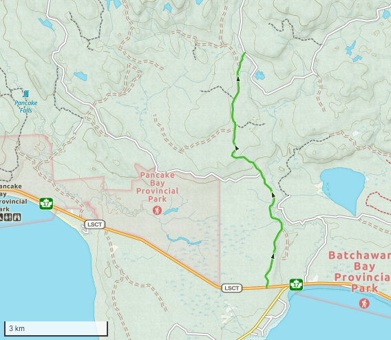
Peter Breccia Access Plan
Via Carp Lake Road
Distance: 20.1 km

Route Overview
From Sault Ste Marie follow Hwy 17 North 68 km to Carp River Road. Follow the road for 8.1 km, turn right onto Jones Road and continue East 3.2 km. Turn North at the fork onto logging road and continue 8.8 km to the end of the road. Proposed drill hole # 1 is 334 m from that location.

Current Obstacles
Location: 16T 687934.00 m E 5210915.00 m N


Log Bridge / Culvert
This bridge is in the middle of the logging road, it would have supported loaded log trucks in the past. No action required.
Location: 16T 685382.00 m E 5209417.00 m N

Ditch 1
Large ditch where culvert has been pulled. Approximately 8 feet deep and 10 feet wide. Bypass will be required.
Location: 16T 687455.00 m E 5210795.00 m N

Potential bypass to the south of ditch. Water in creek is proximally 4" deep. Some trees will need to be removed in oder for the drilling equipment to get through.
Ditch 2
Small ditch where culvert has been pulled. Approximately 6 feet deep and 4 feet wide. Water is approximate 5"deep. Suggest grading slope on each side of ditch.
Location: 16T 687934.00 m E 5210915.00 m N

Ditch 3
Two ditches where culverts have been removed. Approximately 6 feet deep and 20 feet wide. Water is approximate 12"deep. Bypass Required
Location: 16T 688762.00 m E 5212867.00 m N

Potential bypass to the East of ditches. Water in creek is proximally 12" deep. Some trees will need to be removed.
Location: 16T 687934.00 m E 5210915.00 m N
Existing Roads and Staging Areas
Carp River Road
Carp river road is a partially maintained road. It has been maintained well this year as this is the main access road for a Sterling exploration project and a forestry program in the area. It has a solid base and is passable by truck. Currently it is being plowed (single lane) by Sterling up to Mamainse Lake. There is a staging area that equipment can be loaded and unladed at km 7.

Carp River Road
Carp River Road Staging Area

Jones Road
Jones Road is a non maintained road with a good base. This road can be traveled by truck in the summer up to where the culvert (ditch 1) has been pulled. ATV and Snowmobile can bypass the ditch to the South. This road should not require any work other than plowing and bypassing ditch 1 to get drill equipment to site. Jones Road also continues past the logging road turn off at km 3.2 and extends to meet up with Tribag Mine Road at km 11.8 . This can be used as an alternate route back to Hwy 17 if required, however that section of the road is rough with washouts and road extensive erosion.


Logging Road
The final stretch of road is an inactive logging road. The road was built in 2015 and the area had been logged between 2019 and 2021 by Clergue Forest Management Inc who still hold responsibility for the road. There are small tag alders throughout the 8.8 km of road. Other than the two ditches (2, and 3) no additional work should be required on the road other than plowing.


